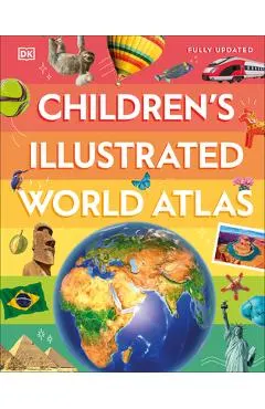
Children's Illustrated World Atlas
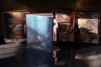
From Bolivia's bustling markets to the massive and scorching Sahara Desert, see the world with this beautifully illustrated atlas.
La cel mai bun preț din ultima lună (58,49 lei)Unde cât costă
| Magazin | Preț | Istoric | |
|---|---|---|---|
LI Litera |
58,49 lei | la minimul propriu | Vezi în magazin |
LB Libris ISBN 9780593842720 |
100,39 lei | minim aici: 89,23 lei | Vezi în magazin |
Prețurile vin automat din listele magazinelor și se mai schimbă între timp. Cel care contează e cel din coșul magazinului, la plată. Linkurile către magazine sunt de parteneriat: dacă cumperi, luăm un comision de la magazin. Pe tine nu te costă nimic în plus, iar ordinea de mai sus e strict după preț.
Cum s-a mișcat prețul
Ce am observat noi
la minimToate cifrele de mai sus ies din ce am notat noi, în fiecare noapte. Nu le-am luat de nicăieri.
În fiecare zi luăm cel mai mic preț dintre toate magazinele și îl punem pe grafic. Linia verde e cel mai jos a coborât în ultima lună.
Lasă-ne adresa și îți scriem dacă scade sub 58,49 lei. Un singur e-mail, când chiar se întâmplă ceva. Îți cerem întâi o confirmare, și te poți retrage oricând dintr-un click.
Întrebări frecvente
Cât costă Children's Illustrated World Atlas?
Cel mai ieftin îl găsești la Litera, cu 58,49 lei, din 2 magazine comparate. Verificăm cifra în fiecare zi, direct din lista de prețuri a magazinului.
Este reducerea la Children's Illustrated World Atlas una reală?
Nu chiar. Costă 58,49 lei, adică exact cât l-am văzut cel mai ieftin în ultima lună. Nu e o scădere nouă — dar nici nu plătești mai mult decât cei care au prins momentul bun.
Care a fost cel mai mic preț la Children's Illustrated World Atlas?
Cel mai ieftin l-am prins la 58,49 lei — adică exact cât costă azi. Îl urmărim de 60 zile.
Merită să compar prețul la Children's Illustrated World Atlas?
Da, și diferența nu e mică: 41,90 lei între cel mai ieftin și cel mai scump magazin. Același produs, aceeași cutie. Doar altă etichetă.
Ce zice magazinul despre el
From Bolivia's bustling markets to the massive and scorching Sahara Desert, see the world with this beautifully illustrated atlas. Children's Illustrated World Atlas is divided into six main sections, each devoted to a continent. Within each continent, a country or a region is explored in detail through stunning maps showcasing cities, towns, rivers, mountain ranges, and other geographical features. Apart from the geography of a region, Children's Illustrated World Atlas also provides interesting information about the people, their traditions, politics, and economics through spectacular images and snippets of facts. Take a trip around the world with Children's Illustrated World Atlas, from the majestic Himalayas to the Carnival of Venice. This colorful and comprehensive book is the perfect addition to every book shelf at home or school. nTake young readers on the ultimate round-the-world trip with this impressive atlas - packed full of beautiful illustrations and photographs. n nDiscover the world map-by-map with this exciting world atlas book for children, featuring more than 50 maps! Each page is filled with fascinating information, facts and colorful illustrations of our world. Children aged 9-12 will love to learn all about the many countries, cultures and people of the world through vibrant maps. Fascinating facts, local stories, vivid pictures, and clear, satellite-based maps together make this atlas a global yet personal experience for young readers. This illustrated atlas book for children offers: n n- Bite-sized information giving the profiles, facts, stats and flags of every country. n- Pictures and stories explaining the society, culture and history of each region. n- Maps created using satellite imagery providing a clear view of the world map-by-map. n- A variety of topics covered, including population density, wealth, and internet access shown through graphics. From Bangkok's floating markets to the carnival in Venice, the Children's Illustrated World Atlas brings together views from windows all over the world. This illustrated atlas not only portrays regions, such as the Siberian wastes, with beautifully detailed maps but also describes the peoples who live there nTake young readers on the ultimate round-the-world trip with this impressive atlas - packed full of beautiful illustrations and photographs. Discover the world map-by-map with this exciting world atlas book for children, featuring more than 50 maps! Each page is f
Descrierea e luată de la Libris.
Alte cărți de Dk


Produse similare din Cărți pentru copii
Vezi categoria →